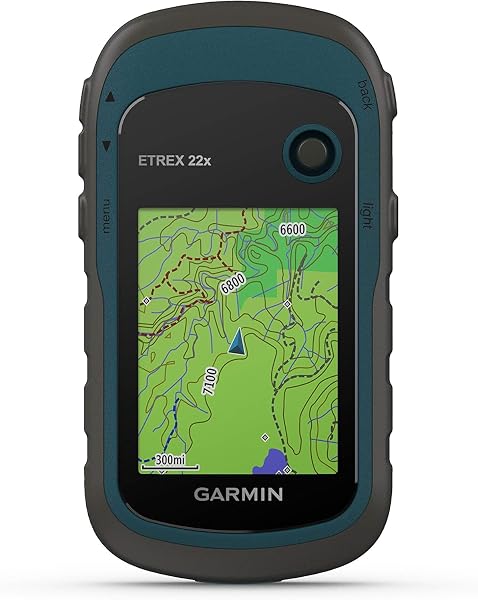
Garmin eTrex 22x
8.6Editor score2.2-inch color display
GPS and GLONASS
8 GB internal storage
25-hour AA battery
Find the right hiking gps for 2026. We compare 10 standout options by build quality, useful features, owner feedback, value, and everyday trade-offs.
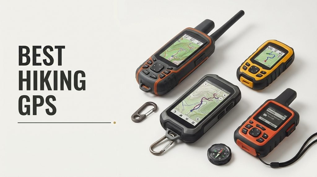
Choosing a hiking GPS for 2026 means weighing display readability, satellite system support, battery life, preloaded maps, waterproofing, and whether you need satellite messaging for off-grid safety. We compare 10 standout handheld and wrist-mounted models across these factors so you can match a device to your typical terrain, trip length, and whether you venture beyond cell coverage.
Handheld GPS units range from compact button-operated navigators under $150 to premium touchscreen models with two-way satellite communication and SOS. The right choice depends on how deep into the backcountry you travel, whether you need to share your location with loved ones, and how much you value features like multi-band GNSS, barometric altimeters, and large color displays.
This guide breaks down each model’s strengths and limitations so you can decide between a basic trail navigator, a feature-rich mapping device, or a satellite communicator that keeps you connected far from cell towers. Each review highlights practical tradeoffs around weight, battery runtime, control layout, and real-world usability on the trail.
We compared 10 handheld and wrist-mounted GPS devices using the details that matter on the trail: display size and sunlight readability, GNSS satellite support, battery life, preloaded mapping, waterproof rating, sensor suite including compass and altimeter, satellite messaging capability, control layout, storage capacity, and overall value. The notes focus on practical trade-offs between weight, feature depth, and off-grid safety so each pick connects to how hikers actually navigate, record tracks, and stay safe in the backcountry.


Compare key features, scores, and current prices side by side. A shorter feature list means fewer details were available, not necessarily fewer capabilities.


The Garmin GPSMAP H1i Plus represents Garmin's top-tier approach to handheld navigation, combining a 3.5-inch sunlight-readable touchscreen with rugged physical buttons for the best of both input methods. The scratch-resistant display works with gloves, and customizable quick-action buttons ensure fast access to critical functions in cold, wet, or gloved conditions. For users who want flagship capability without compromises, this hybrid interface is a meaningful advantage.
We may earn a commission when you buy through this link, at no additional cost to you.
InReach Plus satellite technology dramatically expands communication capability beyond basic messaging. Users can send and receive text messages, exchange photos, share voice messages, and trigger interactive SOS alerts through the 24/7 Garmin Response center. LiveTrack location sharing keeps family and teammates updated in real time. These expanded communication options are genuinely useful for extended expeditions, group trips, and situations where confirming your status to others matters.
Multi-band GPS and multi-GNSS support provide superior accuracy in challenging environments, while built-in ABC sensors deliver barometric, compass, and altitude data for comprehensive navigation support. Ascent planning anticipates upcoming climbs on your route, which is particularly useful for mountaineers and backpackers. The MIL-STD 810 construction withstands water, shock, vibration, and extreme temperatures. The built-in LED flashlight and loud siren add tangible emergency safety value.
The ability to send photos and voice messages via satellite is a meaningful upgrade over text-only communication for several reasons. Photos can confirm conditions to teammates planning to join you, document injuries for medical consultation, or share key route information. Voice messages convey tone and detail that text messages cannot. For professional guides, expedition leaders, and serious backcountry users, these capabilities justify the premium pricing.
This GPS is designed for serious backcountry professionals, extended expedition users, and anyone who wants the most capable handheld available with no compromises. The bundle format adds useful accessories including battery pack, cables, and charging adapters. If you don’t need the expanded photo and voice messaging or the premium feature set, less expensive handhelds provide excellent core navigation. For buyers who want flagship capability, this is the top choice.
Casual hikers or budget-conscious buyers who don’t need flagship features and premium satellite communication capabilities.
We may earn a commission when you buy through this link, at no additional cost to you.
The Garmin eTrex 22x hits a sensible middle ground for hikers who want proven Garmin reliability and preloaded mapping without stepping up to a premium handheld. The 2.2-inch sunlight-readable color display works well on bright trail days, and the TopoActive maps include routable roads and trails for both hiking and cycling. For day hikers and weekend backpackers who stay on established routes, this provides more than enough navigation capability.
We may earn a commission when you buy through this link, at no additional cost to you.
Dual satellite system support, with GPS and GLONASS, improves tracking accuracy in challenging environments like dense tree cover, canyons, and steep terrain where a single satellite system might struggle. The 25-hour battery life on 2 AA batteries is enough for most multi-day trips, and the ability to swap in fresh batteries on the trail eliminates the recharge anxiety that comes with sealed lithium devices. Spare AAs are cheap and easy to pack.
The 8 GB of internal memory holds a substantial amount of mapping data, and the microSD slot lets you add additional map regions or specialty content as needed. The physical buttons are reliable in cold weather, wet conditions, and when wearing gloves, which touchscreens cannot always claim. Setup is straightforward through Garmin’s software, and the device pairs with Garmin Explore for trip planning and track review.
GLONASS is Russia’s global navigation satellite system that works alongside GPS to provide more satellites in view at any given time. In dense forests, deep canyons, or heavily built environments, having both GPS and GLONASS available often means faster lock-on times and more consistent tracking accuracy. For hikers who venture into challenging terrain, dual satellite support is a meaningful upgrade over GPS-only devices.
This GPS is a strong fit for day hikers, scouts, and casual backpackers who want a trusted handheld with maps included and don’t need advanced sensors or satellite messaging. If you need a 3-axis compass, barometric altimeter, or large touchscreen, step up to the eTrex 32x or GPSMAP series. For straightforward trail navigation at a reasonable price, the 22x is a dependable choice.
Serious backcountry users who need a 3-axis compass, barometric altimeter, or satellite messaging capability for safety-critical trips.
We may earn a commission when you buy through this link, at no additional cost to you.
The Garmin eTrex 32x builds on the 22x platform by adding two sensors that make a real difference for serious hikers: a 3-axis electronic compass and a barometric altimeter. The 3-axis compass works even when the device isn't held level, which matters when you're reading bearings on a slope or while moving. The barometric altimeter provides more accurate elevation data than GPS alone and can also indicate changing weather by tracking pressure trends.
We may earn a commission when you buy through this link, at no additional cost to you.
Core navigation features match the 22x, with the 2.2-inch sunlight-readable color display, GPS and GLONASS satellite support, 8 GB of internal memory with microSD expansion, and preloaded TopoActive maps for routable trail and road navigation. The 25-hour battery life on 2 AA batteries supports extended trips without recharging, and the physical buttons remain reliable in all weather conditions.
The added sensors genuinely matter for mountain hiking, cross-country navigation, and anyone who learns to use a map and compass as a backup to GPS. The altimeter helps you track your position on topographic maps by matching your elevation to contour lines, which is particularly useful when trails are faint or when navigating in fog where visibility is limited. The compass provides reliable bearings for triangulation and route-finding when GPS signals are degraded.
A barometric altimeter measures elevation by sensing atmospheric pressure, which is typically more accurate than GPS-derived elevation in mountainous terrain. It also responds instantly to elevation changes, making it useful for tracking ascents and descents in real time. Watching pressure trends over time can indicate approaching weather changes, which is valuable information for multi-day backcountry trips where conditions can shift quickly.
This GPS suits hikers who venture into more challenging terrain and value the added navigation precision that a compass and altimeter provide. If you only hike on well-marked trails and don’t need the extra sensors, the eTrex 22x saves money. For buyers who want Garmin reliability with professional-grade navigation sensors in a compact handheld, the 32x delivers meaningful upgrades.
Casual day hikers who stay on marked trails and don’t need the additional cost of advanced navigation sensors.
We may earn a commission when you buy through this link, at no additional cost to you.
The Garmin GPSMAP 65 is one of the best all-around handheld navigators for serious hikers who want top-tier accuracy without stepping up to a satellite communicator. Its headline feature is expanded global navigation satellite system support with multi-band technology, which uses multiple frequencies from each satellite to resolve position with greater precision. In steep canyons, dense forests, and urban environments where signals bounce or weaken, this provides noticeably better tracking than single-band receivers.
We may earn a commission when you buy through this link, at no additional cost to you.
The 2.6-inch sunlight-readable color display is larger than the eTrex series, making map viewing more comfortable and reducing the need to scroll or zoom frequently. Preloaded TopoActive mapping covers trails and roads, and the included federal public land map (US only) adds valuable context for hunting, hiking, and other activities on public lands. Compatibility with the Garmin Explore website and app supports trip planning, waypoint management, and field data review.
Button-operated controls remain reliable in all weather conditions, with gloves, and in cold temperatures where touchscreens can become unresponsive. The device accepts routable navigation input and provides turn-by-turn guidance along planned routes. The build quality meets Garmin’s standards for ruggedness, with waterproofing suitable for rain, splashes, and brief immersion.
Multi-band GNSS receivers use two or more radio frequencies from each satellite to correct for atmospheric interference and signal reflections. This dramatically improves position accuracy in challenging environments where single-band receivers may wander or lose lock. For hikers in deep canyons, dense tree cover, or near tall cliffs, multi-band support often means the difference between consistent tracking and frustrating signal gaps.
This GPS is an excellent choice for serious hikers, hunters, and backcountry users who prioritize navigation accuracy and reliability over touchscreen convenience. If you need satellite messaging for safety, step up to the GPSMAP 67i. For buyers who want the best navigation performance in a traditional button-operated handheld, the GPSMAP 65 is one of the strongest options available.
Hikers who need two-way satellite messaging or an SOS button for off-grid emergency communication.
We may earn a commission when you buy through this link, at no additional cost to you.
The Garmin eTrex SE delivers exceptional battery life and modern multi-GNSS support at one of the lowest prices in the Garmin handheld lineup. The 168-hour standard mode and 1,800-hour expedition mode on two AA batteries put this well ahead of most competitors, which is a serious advantage for extended trips where recharging isn't practical. For thru-hikers or anyone planning long backcountry expeditions, this battery performance alone can justify the choice.
We may earn a commission when you buy through this link, at no additional cost to you.
Multi-GNSS support covers five global satellite systems: GPS, GLONASS, Galileo, BeiDou, and QZSS. This broad compatibility ensures reliable tracking in virtually any environment, including locations where some satellite constellations have weaker coverage. The digital compass provides accurate heading information even when stationary, which is a useful feature for route planning and bearing checks that cheaper devices often lack.
Pairing with the Garmin Explore app on a smartphone unlocks additional capabilities, including wireless software updates, detailed trip planning, Active Weather forecasts, smart notifications, and expanded mapping options. Automatic cache updates from Geocaching Live make this a strong choice for geocachers. The IPX7 water-resistance rating handles rain and brief immersion without issue.
Expedition mode reduces GPS sampling to extended intervals, typically every 30 minutes or longer, which dramatically cuts power consumption while still recording your overall route. This is ideal for long trips where you don’t need second-by-second tracking but want a general record of where you traveled. Most devices with expedition mode can run for weeks or even months on a single set of batteries in this configuration.
This GPS is a strong fit for budget-conscious hikers, long-distance backpackers who prioritize battery life, and anyone who uses a smartphone companion for detailed trip planning. If you need preloaded detailed topo maps on the device itself, step up to the eTrex 22x or 32x. For buyers who want modern satellite support and all-day-plus battery life at a reasonable price, the eTrex SE is hard to beat.
Hikers who want preloaded detailed topographic maps on the device without needing to add mapping separately.
We may earn a commission when you buy through this link, at no additional cost to you.
The Garmin inReach Mini 2 is less of a traditional GPS and more of a lifeline for backcountry travelers. Its compact size and lightweight design make it easy to clip to a pack strap or carry alongside a dedicated handheld GPS. The core value proposition is global two-way satellite messaging and interactive SOS capability through the Iridium satellite network, which works in locations where cell coverage simply doesn't exist.
We may earn a commission when you buy through this link, at no additional cost to you.
Two-way messaging lets you communicate with friends, family, or emergency services from anywhere in the world. The interactive SOS feature contacts Garmin Response, a 24/7 staffed emergency coordination center that can direct search and rescue efforts to your exact location. For solo hikers, remote backpackers, or anyone venturing into terrain where cell service is unavailable, this capability can genuinely save lives.
TracBack routing helps you navigate back to your starting point by retracing your route, which is a useful feature when visibility is poor or when you’ve been exploring without planning a specific return path. The digital compass provides accurate heading information even when stationary, and the device shares your location through MapShare or embedded coordinates in messages. Integration with the Garmin Explore app enables detailed trip planning and topographical mapping on a connected smartphone.
InReach devices require an active subscription to use satellite messaging and SOS features. Plans range from basic monthly subscriptions for casual users to annual plans with higher message allowances for frequent users. Freedom plans let you activate and deactivate service month-to-month, while annual plans typically cost less overall. Factor the ongoing subscription cost into your total ownership budget when considering an inReach device.
This device is essential for solo backcountry travelers, remote adventurers, international trekkers, and anyone who ventures far from reliable cell coverage. The ongoing satellite subscription is a real cost consideration, but the safety value for serious off-grid use is substantial. If you only hike in areas with cell coverage or near well-traveled routes, a standard handheld GPS without satellite messaging may be sufficient.
Hikers who stay in areas with reliable cell coverage or who don’t want the ongoing cost of a satellite subscription.
We may earn a commission when you buy through this link, at no additional cost to you.
The Garmin GPSMAP 67i combines a premium handheld GPS with built-in inReach satellite technology, essentially merging two devices into one package. The large 3-inch sunlight-readable color display makes map viewing much more comfortable than smaller handhelds, and the preloaded TopoActive mapping provides immediate navigation capability. For serious hikers who need both precise navigation and off-grid communication, this consolidation reduces the number of devices you need to carry.
We may earn a commission when you buy through this link, at no additional cost to you.
Two-way messaging and interactive SOS work through the global Iridium satellite network, with 24/7 Garmin Response coordination for emergencies. Multi-band GNSS support ensures accurate positioning in challenging terrain, including canyons and dense forests. Downloadable satellite imagery adds visual context to your location, and Wi-Fi connectivity enables direct map downloads to the device without needing a computer connection.
Battery life is impressive for a feature-rich device: up to 165 hours in 10-minute tracking mode and up to 425 hours in expedition mode with 30-minute tracking intervals. The internal rechargeable lithium battery charges via USB-C, which is becoming the standard connector for most outdoor electronics. Smartphone pairing unlocks additional features including active weather forecasts and Geocaching Live integration.
Carrying a single device that handles both navigation and satellite communication reduces pack weight, simplifies your gear list, and ensures you have both capabilities available without juggling multiple devices. The downside is that a failure in one component disables both functions. For backcountry safety, some users prefer separate devices for redundancy. Weigh the convenience benefits against the single-point-of-failure risk when choosing between integrated and separate solutions.
This GPS is ideal for serious backcountry users who want the convenience of one device for both navigation and emergency communication. The renewed condition offers meaningful savings over a new unit while providing the same core functionality. If you only need navigation or already own a satellite communicator, a standard handheld GPS will cost less. For buyers who want premium all-in-one capability, the 67i is a top choice.
Budget-conscious buyers who only need navigation without satellite messaging capability.
We may earn a commission when you buy through this link, at no additional cost to you.
This 3.2-inch handheld GPS offers a notably larger display than Garmin's budget handhelds at a price point that remains accessible. The bright, sunlight-readable screen makes map viewing more comfortable, and physical buttons provide reliable control in all weather conditions. For buyers who want a larger display without stepping up to premium pricing, this unit presents an appealing specification sheet.
We may earn a commission when you buy through this link, at no additional cost to you.
Multi-GNSS support covers GPS, Galileo, BeiDou, and QZSS, providing location accuracy within approximately 6 feet. This broad satellite support helps maintain reliable tracking in various environments, including under tree cover and near large structures. The preloaded USA Topo maps give you immediate navigation capability for domestic hiking, and the generous 32 GB of internal memory allows significant additional map storage.
A 3-axis compass and barometric altimeter provide professional-grade sensor data, including accurate bearings when stationary and precise elevation readings for topographic navigation. The IP66 waterproof rating handles heavy rain and splashes, and the rechargeable battery provides up to 36 hours of operation on a full charge via standard USB-C. The anti-slip design improves grip in wet or sweaty conditions.
When considering GPS devices from smaller or newer brands, carefully research owner reviews, warranty terms, and the availability of software updates. Established brands like Garmin invest heavily in long-term software support, which affects how useful a device remains over years of use. Smaller brands may offer better upfront value but less certainty about long-term software compatibility and customer support. Factor these considerations into your purchase decision.
This GPS is a potential fit for budget-conscious hikers who want a larger display and modern sensors without paying premium prices. The 3.9-star owner rating suggests reading recent reviews carefully to understand real-world reliability and support quality. For buyers who prioritize spec sheet value over established brand support, this unit offers an attractive feature set for the money.
Buyers who prioritize established brand reputation, proven long-term support, and robust ecosystem integration.
We may earn a commission when you buy through this link, at no additional cost to you.
The Garmin Montana 710 brings a tablet-like 5-inch glove-friendly touchscreen to the handheld GPS category, which transforms the mapping experience compared to smaller devices. Reading detailed topographic maps, planning routes, and reviewing track data all benefit significantly from the extra display real estate. For serious expedition users, hunters working large territory, and vehicle-based explorers, the Montana's size is a feature rather than a drawback.
We may earn a commission when you buy through this link, at no additional cost to you.
The 32 GB of internal memory stores extensive mapping libraries, satellite imagery, and route data, and the included TopoActive maps provide immediate navigation capability. An Outdoor Maps+ subscription unlocks ongoing access to premium mapping content via Wi-Fi downloads directly to the device. Downloadable high-resolution satellite imagery provides photorealistic overhead views and lets you create waypoints based on identifiable landmarks.
Rugged construction is rated to MIL-STD 810 for thermal, shock, and vibration resistance, plus IPX7 for water-resistance. The rechargeable lithium-ion battery pack provides up to 24 hours in GPS mode and up to 432 hours in expedition mode, and the device can also run on traditional AA batteries for flexibility in the field. USB-C charging keeps the device compatible with modern cables and power banks.
A larger touchscreen transforms how you interact with maps and route data. Reading contour lines becomes easier, planning routes feels more natural, and reviewing track history provides more useful information at a glance. The tradeoff is weight, bulk, and typically higher cost. For activities like hunting, boating, or vehicle-based exploration where the device is often stationary or mounted, a large touchscreen is a major benefit.
This GPS is a strong fit for serious expedition users, professional guides, hunters, and anyone who values a large display for detailed mapping work. The size and weight make it less suitable for ultralight backpacking or situations where you want a device that fits easily in a pocket. For buyers who prioritize display size and expedition-grade capability over compactness, the Montana 710 is one of the most capable handhelds available.
Ultralight backpackers or hikers who want a compact, pocketable device for minimal weight on long trips.
We may earn a commission when you buy through this link, at no additional cost to you.
The Garmin Foretrex 801 takes a different approach to GPS navigation by mounting on your wrist, keeping your hands free for other tasks. This form factor is particularly valued by military users, search and rescue teams, and hikers who want to glance at bearings and position without stopping to pull out a handheld. The monochromatic screen is easy to read in various lighting conditions and compatible with night vision goggles, which indicates its tactical heritage.
We may earn a commission when you buy through this link, at no additional cost to you.
Multi-band signal reception technology provides improved position accuracy compared to older single-band wrist units. Advanced sensors include a 3-axis accelerometer, 3-axis compass, and barometric altimeter, giving you comprehensive navigation data on your wrist. Stealth mode stops storing and sharing GPS data while disabling wireless connectivity, which addresses operational security needs. A kill switch can erase device memory in case of security concerns.
Jumpmaster mode calculates high-altitude release points according to military guidelines, reflecting the Foretrex line’s history with airborne operations. For civilian users, this specialized feature isn’t typically needed, but the overall accuracy and reliability translate well to hiking, orienteering, and backcountry travel. The device pairs with compatible inReach satellite communicators to display incoming messages on the wrist screen, extending functionality for safety-conscious users.
Wrist-mounted GPS units offer meaningful advantages for activities where you need both hands free: climbing, operating equipment, carrying heavy loads, or moving quickly through terrain. The ability to glance at your wrist for position and bearing without stopping to retrieve a handheld can genuinely improve safety and efficiency. The tradeoff is a smaller display and more limited mapping compared to traditional handhelds, so pair wrist units with paper maps or a smartphone for detailed route planning.
This GPS is a strong fit for military users, SAR teams, hunters who need hands-free navigation, and backcountry travelers who want wrist-mounted convenience. If you need detailed color mapping or a large display, a traditional handheld will serve you better. For buyers who prioritize hands-free operation and tactical-grade features in a wrist-mounted device, the Foretrex 801 is the standout choice.
Hikers who want detailed color topographic maps and larger displays for comprehensive on-device navigation.
We may earn a commission when you buy through this link, at no additional cost to you.
Selecting a hiking GPS involves balancing display size, satellite support, battery life, mapping, and communication features against the terrain you explore and the risks you want to manage. The factors below cover the most important decision points so you can match a device to your actual hiking style rather than overbuying features you’ll never use.
Modern GPS devices use multiple global navigation satellite systems (GNSS) to improve accuracy and reliability. The core system is GPS (operated by the US), but adding GLONASS (Russia), Galileo (Europe), BeiDou (China), and QZSS (Japan) provides more satellites in view at any given time. More satellites typically mean faster lock-on, better accuracy in challenging environments, and more reliable tracking when some satellites are blocked by terrain or vegetation.
Multi-band GNSS takes accuracy a step further by using multiple radio frequencies from each satellite to correct for atmospheric interference and signal reflections. This technology produces noticeably better results in canyons, dense forests, urban areas, and other locations where single-band signals can wander or lose lock. Devices like the Garmin GPSMAP 65 and 67i feature multi-band support, which is a meaningful upgrade for serious backcountry users.
For general hiking on marked trails, standard dual-system support (GPS plus GLONASS or Galileo) is sufficient. For technical terrain, deep canyons, or dense forests, prioritize multi-band GNSS for the best accuracy.
Display size directly affects how comfortable it is to read maps, review tracks, and interact with menus. Compact handhelds like the eTrex series use 2.2-inch screens that keep the device pocket-friendly but limit how much map detail you can see at once. Mid-size units like the GPSMAP 65 offer 2.6-inch displays that provide a better balance of readability and portability. Larger units like the Garmin Montana 710 feature 5-inch touchscreens that transform the mapping experience but add weight and bulk.
Sunlight readability matters more than resolution for outdoor use. A screen that washes out in bright sun is nearly useless on exposed trails, regardless of pixel count. Transflective displays, which use ambient light to improve visibility, work much better outdoors than standard LCD screens. Most quality hiking GPS units use transflective or similar sunlight-readable technology; verify this before purchasing any device intended for outdoor use.
If you hike mostly on well-marked trails and want a pocket-friendly device, 2.2-2.6 inch displays are sufficient. For detailed map work or extended expeditions, consider stepping up to 3-inch or larger displays.
Battery life becomes critical on multi-day trips where recharging isn’t practical. GPS devices vary enormously in battery performance, from 24-25 hours on standard tracking to 400+ hours in expedition mode on some premium units. Expedition mode reduces GPS sampling frequency to extend runtime, which is ideal for long trips where you don’t need second-by-second tracking.
Power source matters as well. AA battery compatibility is a major advantage for extended trips because you can carry spare batteries easily and swap them in the field. Devices like the Garmin eTrex series and Montana 710 support AA batteries, often in addition to rechargeable options. Fully sealed lithium-ion units like the GPSMAP 67i offer better weatherproofing and higher capacity but require USB power to recharge, which may require solar panels or power banks on extended trips.
For day hikes and overnight trips, any modern GPS has sufficient battery life. For multi-day backpacking, prioritize AA battery compatibility or extended expedition modes. For thru-hiking or expedition use, the eTrex SE’s 1,800-hour expedition mode is exceptional.
Preloaded mapping saves significant setup time and provides immediate navigation capability out of the box. Most Garmin handhelds come with TopoActive maps that include routable trails and roads for North America. Some units add specialized content like federal public land maps for hunting and recreation. The ability to download additional maps via Wi-Fi, USB, or microSD card lets you expand coverage for international travel or specialized needs.
Mapping subscription services like Outdoor Maps+ provide ongoing access to premium content including detailed topographic maps, satellite imagery, land ownership data, and historical maps. These subscriptions can be valuable for serious users who need current, high-quality mapping across multiple regions. Factor subscription costs into your total ownership budget if you need premium mapping capabilities.
For domestic hiking on marked trails, preloaded TopoActive maps are typically sufficient. For international travel, specialized activities, or detailed topographic work, plan for additional mapping purchases or a mapping subscription.
A 3-axis electronic compass provides accurate heading information even when the device isn’t held level, which matters when you’re reading bearings on a slope or while moving. A barometric altimeter measures elevation more accurately than GPS alone and can indicate approaching weather by tracking pressure trends. Together, these sensors (often called ABC sensors when combined with a barometer) transform a GPS into a comprehensive navigation tool.
Entry-level units like the Garmin eTrex 22x omit these sensors to save cost, while more capable units like the eTrex 32x and GPSMAP series include them. For hiking on marked trails in moderate terrain, you can navigate adequately without these sensors. For mountain hiking, cross-country navigation, or situations where weather awareness matters, the extra sensors provide meaningful value.
If you learn to use a map and compass or hike in mountainous terrain, prioritize a GPS with 3-axis compass and barometric altimeter. For casual trail hiking, basic GPS-only devices save money without compromising safety on established routes.
Satellite communicators like the inReach Mini 2 and GPSMAP 67i provide two-way messaging and interactive SOS capability through the Iridium satellite network, which covers the entire globe. This capability is genuinely life-saving for solo hikers, remote backcountry users, and anyone venturing beyond cell coverage. The interactive SOS feature contacts a 24/7 emergency coordination center that can direct search and rescue efforts to your exact location.
Satellite communication requires an active subscription, which adds ongoing cost beyond the device itself. Plans range from basic monthly subscriptions for occasional users to annual plans with higher message allowances. Weigh the subscription cost against the safety value for your specific usage pattern. For infrequent users, flexible freedom plans let you activate and deactivate service as needed.
For solo hikers, remote adventurers, or anyone traveling beyond cell coverage, satellite communication capability is worth serious consideration. If you only hike in areas with reliable cell service, a standard GPS without satellite messaging will cost less to own and operate.
Hiking GPS devices need to handle rain, splashes, and occasional immersion without failing. The IPX7 rating, common across quality handhelds, indicates protection against immersion in up to 1 meter of water for 30 minutes. This handles typical outdoor use including heavy rain, stream crossings, and accidental drops into puddles. The IP66 rating provides strong protection against powerful water jets but may not handle immersion as well as IPX7.
Beyond waterproofing, overall ruggedness matters for devices that may be dropped, crushed in packs, or exposed to extreme temperatures. MIL-STD 810 certification tests devices against shock, vibration, thermal extremes, and other environmental stresses. Devices like the Garmin Montana 710 and GPSMAP H1i Plus meet these military standards, which translates to better reliability in demanding conditions.
For most hiking in temperate climates, IPX7 waterproofing and standard rugged construction are sufficient. For extreme environments, mountaineering, or professional use, prioritize MIL-STD 810 certified devices for maximum durability.
Button-operated GPS devices work reliably in all conditions, including with gloves, in cold temperatures, and when the device is wet. The tradeoff is slower navigation through menus and less intuitive map interaction. Devices like the Garmin eTrex and GPSMAP 65 use button controls that have proven reliable across generations of handhelds.
Touchscreen devices offer more intuitive map navigation, faster menu access, and a more modern interface. The downside is that touchscreens can be unresponsive with wet hands, in cold temperatures, or when wearing standard gloves. Glove-friendly touchscreens like those on the Montana 710 and GPSMAP H1i Plus address this limitation, and hybrid designs that combine touchscreen with physical buttons offer the best of both worlds.
For cold-weather hiking, winter use, or demanding conditions where reliability matters most, prioritize button-operated devices or hybrid designs with physical buttons. For general use where touchscreen convenience is appealing, touchscreen handhelds provide an excellent experience.
Traditional handheld GPS units offer the largest displays and most comprehensive feature sets, but require you to carry them in a pocket, pack, or chest harness. This is the standard approach for serious navigation and works well for most hiking scenarios. Handhelds typically run from about 5-10 ounces depending on size and features.
Wrist-mounted GPS devices like the Garmin Foretrex 801 keep navigation data visible without requiring you to retrieve a device from your pocket. This hands-free design is particularly valuable for climbing, carrying equipment, or situations where speed matters. The tradeoff is smaller displays and more limited mapping compared to handhelds, so wrist units work best paired with paper maps or a smartphone for detailed planning.
For general hiking and comprehensive navigation, choose a traditional handheld. For activities requiring hands-free operation (climbing, SAR, tactical use), consider a wrist-mounted GPS as a primary or supplementary device.
Hiking GPS devices in this guide span from under $150 to over $1,000, reflecting significant variation in display size, satellite features, mapping, and build quality. Entry-level handhelds in the $150-$200 range handle most casual hiking needs, while mid-range devices around $300-$500 add premium accuracy, larger displays, and advanced sensors. Flagship units with satellite communication push into $500-$1,000+ territory.
When evaluating value, consider the ongoing costs of satellite subscriptions, mapping subscriptions, and potential replacement batteries. Also factor in the long software support that established brands like Garmin provide; a 5-year-old Garmin handheld typically still receives firmware updates and ecosystem integration, which affects long-term usability. Less established brands may offer better upfront value but less certainty about long-term support.
Set a budget that matches your actual usage patterns. For occasional casual hiking, entry-level units provide excellent value. For serious backcountry use or professional applications, invest in premium devices with proven reliability and comprehensive feature sets.
Before your first trip, spend time learning your device’s menus, controls, and key features in a familiar environment. Download or install the appropriate maps for your planned hiking area, create test waypoints, and practice marking locations and following routes. Pair your device with the manufacturer’s companion app on your smartphone for trip planning, software updates, and reviewing recorded tracks. Verify battery compatibility and carry spare AA batteries if your device accepts them, especially for extended trips.
On the trail, start a track recording at the trailhead and periodically mark important waypoints such as water sources, junctions, and campsites. Use the compass and altimeter (if available) alongside GPS data for cross-checking position in challenging terrain. Keep the device in a protected pocket or chest harness when not actively navigating to prevent damage and conserve battery. In cold weather, battery life drops significantly, so plan for shorter runtime and consider carrying backup batteries close to your body for warmth.
After each trip, review and export your tracks for future reference, update maps and firmware as new versions become available, and clean the device with a soft damp cloth. Rinse off salt residue after coastal hikes to prevent corrosion. Store the device with batteries removed if you won’t use it for extended periods, which prevents battery leakage damage. For satellite communicators, verify your subscription status before trips and confirm that friends and family know how to interpret messages or alerts from the device. Periodically test the SOS function per manufacturer guidelines (without triggering an actual rescue response) to confirm the device is working correctly.
Smartphones work well for navigation in areas with cell coverage, but dedicated hiking GPS devices offer longer battery life, better waterproofing, superior performance in cold conditions, and functionality that doesn't depend on cell signal. For day hikes near populated areas, a smartphone with offline maps may suffice. For multi-day trips, remote areas, or safety-critical navigation, a dedicated GPS provides important advantages in reliability and endurance.
A hiking GPS primarily helps you navigate using preloaded maps and satellite positioning. A satellite communicator like the inReach Mini 2 enables two-way messaging and emergency SOS through satellite networks that work globally, regardless of cell coverage. Some devices like the GPSMAP 67i combine both capabilities. If you venture into remote areas, a satellite communicator adds significant safety value beyond basic navigation.
Modern hiking GPS units are typically accurate to within 10-15 feet under good conditions, and multi-band GNSS devices can achieve 3-6 foot accuracy in optimal environments. Accuracy degrades in canyons, dense forests, and heavily built areas where signals bounce or are blocked. Multi-GNSS and multi-band support significantly improve accuracy in challenging terrain compared to older GPS-only receivers.
Standard GPS devices for navigation don't require subscriptions; they work entirely from satellite signals and preloaded maps. However, satellite communicators like the inReach series require active subscriptions to use messaging and SOS features. Premium mapping services like Outdoor Maps+ are optional add-ons for users who want expanded mapping content. Factor these ongoing costs into your total ownership budget when considering devices with these features.
Yes, GPS satellite signals work globally, but preloaded maps typically cover specific regions. For international travel, you may need to purchase additional map packages for your destination or subscribe to a mapping service that provides worldwide coverage. Satellite communicators work globally through the Iridium network, though some jurisdictions regulate or prohibit satellite communication devices; verify local regulations before traveling.
GPS is the US-operated global navigation satellite system, while GLONASS is Russia's equivalent system. Modern GPS devices can use both systems simultaneously, which provides more satellites in view and improves tracking accuracy in challenging environments. Devices supporting multiple satellite systems (GPS, GLONASS, Galileo, BeiDou, QZSS) generally provide better performance in forests, canyons, and other difficult locations than GPS-only devices.
Battery life varies dramatically by device and settings, from about 24 hours for premium feature-rich units to 1,800 hours in expedition mode for efficient models like the eTrex SE. For day hikes, any modern GPS has sufficient battery life. For multi-day trips, choose devices with AA battery compatibility (allowing spare battery swaps) or extended expedition modes. Cold weather significantly reduces battery life, so plan accordingly.
Most quality hiking GPS devices accept custom maps through microSD cards, direct downloads via Wi-Fi, or USB connections to a computer. Garmin devices work with GPX files, Garmin Custom Maps, and various third-party map formats. The ability to add custom maps is particularly useful for international travel, specialized activities like hunting, or detailed topographic coverage of specific regions.
Both have advantages depending on your use. Buttons work reliably in all conditions including with gloves, in cold temperatures, and when wet. Touchscreens offer faster navigation and more intuitive map interaction but can be unresponsive in difficult conditions. Hybrid designs that combine touchscreen with physical buttons offer the best of both approaches. For cold-weather or demanding use, buttons or hybrid designs are typically more reliable.
For reliability in remote areas, a dedicated GPS with onboard maps is more dependable than a smartphone app that may fail due to battery drain, cold temperatures, or hardware damage. However, smartphone apps like Gaia GPS and AllTrails offer excellent mapping and are sufficient for many casual hikers who stay within cell coverage. For safety-critical navigation or extended backcountry trips, a dedicated GPS with onboard maps provides important redundancy.
The Garmin GPSMAP 65 stands out as the strongest overall choice for serious hikers, combining multi-band GNSS accuracy, a comfortable 2.6-inch sunlight-readable display, preloaded TopoActive mapping, and proven Garmin reliability in a traditional button-operated handheld. For hikers who want the best navigation performance without stepping up to satellite communication, this device delivers everything you need for confident backcountry navigation.
For different priorities, the Garmin inReach Mini 2 provides essential two-way satellite messaging and SOS for solo and remote backcountry users, the Garmin eTrex SE offers exceptional battery life and modern satellite support at an attractive price, and the Garmin GPSMAP H1i Plus delivers flagship capability with photo and voice satellite messaging for serious expeditions. The Garmin Montana 710 serves hunters and vehicle-based explorers who want a large touchscreen for detailed map work.
The right hiking GPS depends on your terrain, trip length, and safety requirements. Use the comparison table and buying guide to narrow down the features that matter for your actual hiking style. For casual day hikers on marked trails, entry-level handhelds provide excellent value. For serious backcountry users, invest in multi-band GNSS and advanced sensors. For anyone venturing beyond reliable cell coverage, strongly consider satellite communication capability as a potentially life-saving safety investment.