Garmin eTrex 22x
8.6Editor score2.2-inch color display
GPS and GLONASS
8 GB internal storage
25-hour AA battery
Find the right handheld gps for 2026. We compare 10 standout options by build quality, useful features, owner feedback, value, and everyday trade-offs.

Choosing the right handheld GPS for 2026 means balancing satellite support, battery life, mapping quality, and display readability against your specific outdoor activities. We compare 10 standout navigators by the factors that matter most in the field: multi-band GNSS accuracy, waterproofing ratings, preloaded maps, button or touchscreen controls, battery options, rugged construction, and whether the unit genuinely suits hiking, hunting, geocaching, or marine use.
Handheld navigators vary significantly in their approach. Button-operated models like the Garmin eTrex and GPSMAP series excel in cold weather and with gloves, while touchscreen units like the Montana 710 and eTrex Touch offer faster map interaction. Multi-band GPS and expanded GNSS support dramatically improve accuracy in forest canopies, urban canyons, and steep terrain compared to GPS-only receivers.
Whether you need a lightweight backup for day hikes, a floating marine unit for coastal navigation, or a solar-powered expedition device for extended backcountry trips, the picks below cover the most practical options available. Read on to find the handheld GPS that matches your activities, your budget, and the conditions where you actually navigate.
We compared 10 handheld GPS units using the details that actually help an outdoor buyer decide: GNSS and multi-band satellite support, battery life and power options, mapping included out of the box, display size and sunlight readability, waterproofing ratings, control type, rugged construction, and value. The notes focus on practical trade-offs so each pick connects to how people actually navigate in the field, from short day hikes and geocaching to extended backcountry expeditions and marine use.


Compare key features, scores, and current prices side by side. A shorter feature list means fewer details were available, not necessarily fewer capabilities.


The Garmin GPSMAP 65 represents a meaningful step up from the eTrex series by adding expanded GNSS constellation support and multi-band technology, which deliver dramatically improved positional accuracy in challenging environments. For hunters, backcountry hikers, and anyone navigating in steep terrain, urban canyons, or dense forest canopy, this accuracy improvement often means the difference between knowing exactly where you are and guessing based on dead reckoning.
We may earn a commission when you buy through this link, at no additional cost to you.
The 2.6-inch sunlight-readable color display is noticeably larger than the eTrex family’s 2.2-inch screen, which makes map reading easier in the field without requiring frequent zooming. The display works well in direct sunlight thanks to Garmin’s transflective technology, and the physical buttons remain fully functional with gloves on in cold or wet conditions. Button operation also keeps the unit usable when the screen is wet from rain or snow.
Preloaded routable TopoActive mapping plus the federal public land map for US users provides substantial coverage out of the box without needing to purchase additional maps. Compatibility with the Garmin Explore website and app lets you plan trips on your computer or phone, sync waypoints and routes wirelessly, and review tracking statistics after each outing. For buyers who want to build a cohesive outdoor navigation workflow, this integration adds real value.
Traditional GPS receivers use the L1 frequency band only. Multi-band receivers also use the L5 band, which provides better accuracy and resistance to interference and multipath reflections that cause positioning errors in cities and forests. In practical terms, multi-band GPS can keep you within a few feet of your true position in conditions where single-band receivers show errors of 30 feet or more. For precision navigation, this difference matters significantly.
This GPS is the right choice for serious hikers, hunters, and backcountry users who need the best possible accuracy without the complexity or premium pricing of touchscreen flagships. The main tradeoff compared to the eTrex family is the larger body size and higher price, both of which are justified by the multi-band performance advantage. For anyone who has struggled with GPS accuracy under tree cover or in steep country, the GPSMAP 65 is often transformative.
Casual users on open terrain where basic GPS accuracy is sufficient and the premium for multi-band would not deliver meaningful benefits.
We may earn a commission when you buy through this link, at no additional cost to you.
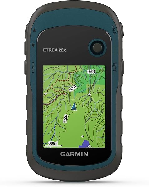
The Garmin eTrex 22x fits the sweet spot for hikers, geocachers, and cyclists who want a dependable Garmin navigator without stepping up to the premium multi-band models. The 2.2-inch sunlight-readable color display handles everyday mapping clearly, and the preloaded TopoActive maps include routable roads and trails that work out of the box for both cycling and hiking without needing additional map purchases.
We may earn a commission when you buy through this link, at no additional cost to you.
Dual satellite support for GPS and GLONASS significantly improves tracking performance under tree cover, in canyons, and in other challenging environments where GPS-only receivers struggle. The 8 GB of internal memory plus the microSD card slot gives you plenty of room to add regional maps, satellite imagery, or detailed city maps for specific trips. Button controls work reliably with gloves on and in wet conditions where touchscreens often fail.
Battery life of up to 25 hours on two AA batteries is a practical sweet spot for weekend trips, and the use of standard AA cells means you can carry spares easily or swap in alkaline, lithium, or rechargeable NiMH batteries depending on the trip. For multi-day backpacking, the ability to replace batteries in the field rather than needing to recharge is a significant advantage over sealed-battery alternatives.
A routable map lets the GPS calculate turn-by-turn navigation along trails and roads, rather than just displaying a static map image. For cyclists following forest road networks or hikers navigating connecting trails, this capability transforms the device from a position marker into an active navigation tool. The TopoActive maps preloaded on the eTrex 22x include routable trails and roads out of the box, which means you can get usable navigation without buying additional map products.
This navigator is the right choice for buyers who want a proven Garmin unit with routable mapping at a mid-range price point. The main tradeoff is the absence of a barometric altimeter and 3-axis compass, which the eTrex 32x adds for a modest step up in price. If elevation data and compass accuracy matter to you, consider the 32x. For straightforward trail navigation and geocaching, the 22x delivers solid value and reliable performance.
Hikers who need barometric altimeter accuracy for serious elevation work or those who want the superior accuracy of multi-band GNSS.
We may earn a commission when you buy through this link, at no additional cost to you.
This compact multi-GNSS navigator provides a non-Garmin alternative that emphasizes a larger display, rechargeable battery convenience, and generous internal memory at a competitive price. The 3.2-inch sunlight-readable screen is noticeably larger than most Garmin eTrex models, which makes map viewing easier for users with less-than-perfect eyesight or those who dislike constant zooming on small displays.
We may earn a commission when you buy through this link, at no additional cost to you.
Multi-GNSS support covering GPS, Galileo, BeiDou, and QZSS delivers positional accuracy within approximately 6 feet, which is competitive with mid-range Garmin units. The 3-axis compass provides accurate heading information even when stationary, and the barometric altimeter adds elevation data for hikers who want to track vertical gain and loss. These sensor additions are features that cost significantly more on comparable Garmin models.
The USB-C rechargeable battery offers up to 36 hours of use per charge, which eliminates the ongoing expense and environmental impact of disposable AA batteries. For users who already carry USB-C cables and power banks for phones and other devices, this standardization simplifies gear planning. The IP66 water resistance handles rain and splashes but is not rated for submersion like some IPX7 and higher units.
USB-C rechargeable batteries like the one in this unit are convenient for day trips and multi-day outings where you can carry a power bank. AA batteries used in Garmin eTrex units let you carry fresh spares and swap them instantly in the field with no recharge time needed. For extended expeditions beyond typical power bank capacity, AA units often prove more practical. For shorter trips and users who value modern charging convenience, rechargeable units like this one are often preferable.
This navigator is the right choice for budget-conscious buyers who want a larger display and rechargeable battery without paying premium Garmin pricing. The main tradeoffs are the lower user rating compared to established Garmin models and the smaller software ecosystem, which means less community support, fewer map options, and less third-party accessory availability. For straightforward hiking and camping use, however, this unit offers compelling specifications at a reasonable price.
Buyers who prioritize Garmin’s established software ecosystem, extensive map library, and strong resale value.
We may earn a commission when you buy through this link, at no additional cost to you.
The Garmin eTrex 32x builds on the eTrex 22x foundation by adding two features that matter significantly for serious hikers and climbers: a 3-axis tilt-compensated electronic compass and a barometric altimeter. The compass provides accurate heading information while the unit is held at any angle, including when you tilt it to read a trail description or map detail. This small convenience becomes major when you are navigating complex trail junctions or trying to orient yourself at a viewpoint.
We may earn a commission when you buy through this link, at no additional cost to you.
The barometric altimeter uses atmospheric pressure to calculate elevation, which is more accurate than GPS-only elevation data and responds faster to changes as you climb or descend. For mountain hikers tracking vertical gain, climbers monitoring altitude for acclimatization, or anyone who wants to correlate position with elevation profile, the barometric sensor delivers tangible benefits over GPS altitude alone.
The 2.2-inch sunlight-readable color display, 8 GB of internal memory with microSD expansion, and 25-hour battery life on AA cells match the eTrex 22x. Preloaded TopoActive maps with routable trails and roads give you working navigation out of the box, and GPS plus GLONASS satellite support provides reliable tracking under moderate tree cover and in canyons.
GPS-only elevation data can vary by 50 feet or more during a single hike, which makes it unreliable for serious elevation tracking. Barometric altimeters measure air pressure directly and typically achieve accuracy within 10 feet or better, with the ability to detect small elevation changes that GPS misses entirely. For hikers who want accurate vertical statistics or who need elevation data for altitude-sensitive activities, barometric sensors are a significant upgrade.
This navigator is the right choice for hikers and mountain users who value compass accuracy and altimeter data over the larger display and multi-band performance of pricier models. The main tradeoff is that the price has climbed close to the GPSMAP 65 territory without offering the newer multi-band capability. If you specifically need the compass and altimeter in the familiar eTrex form factor, this is your model. If you want the best accuracy, the GPSMAP 65 may be the better choice at a similar price point.
Buyers who want the best possible positional accuracy and would prefer multi-band GNSS over the specific sensor combination offered here.
We may earn a commission when you buy through this link, at no additional cost to you.
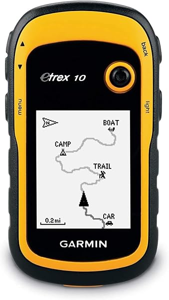
The Garmin eTrex 10 is the entry point into the Garmin handheld ecosystem, offering genuine Garmin reliability at a price that makes GPS navigation accessible to new users and casual outdoor enthusiasts. The 2.2-inch monochrome display is readable in direct sunlight and conserves battery life, though it lacks the color topographic detail of pricier models. For simple geocaching, basic trip tracking, and emergency position reporting, this simplicity is often perfectly adequate.
We may earn a commission when you buy through this link, at no additional cost to you.
The WAAS-enabled GPS receiver with HotFix and GLONASS support delivers fast position acquisition and reliable signals, especially after the first use when the receiver has stored almanac data. IPX7 waterproof rating protects against rain, splashes, and brief accidental immersion, which covers the vast majority of real-world outdoor weather exposure. The included worldwide basemap provides geographic context without delivering detailed trail information.
Paperless geocaching support lets you load caches directly to the device and track your finds without carrying printed sheets, which has become the standard way to geocache efficiently. Two AA batteries provide up to 20 hours of use, and the ability to swap batteries in the field keeps you running on long trips without worrying about charging. Compatibility with Garmin spine mounting accessories lets you attach the unit to packs, bikes, or vehicle mounts.
A simpler GPS like the eTrex 10 has advantages beyond the lower price. Fewer features mean less complexity, which means a shorter learning curve and fewer things to go wrong in the field. For casual users, geocachers, and emergency backup situations, the simplicity translates to reliable performance that just works. More advanced features in premium units deliver real value for serious use but can feel overwhelming for occasional outdoor activities.
This GPS is the right choice for beginners entering the hobby, geocachers who want a dedicated device without smartphone battery drain, or anyone who needs a backup GPS without major investment. The main limitations are the monochrome display and the lack of detailed topographic mapping, which make this unit less useful for serious trail navigation. For point-to-point tracking and basic geocaching, however, the eTrex 10 delivers solid Garmin value.
Serious hikers, hunters, or anyone who needs detailed topographic mapping and color displays for complex navigation.
We may earn a commission when you buy through this link, at no additional cost to you.
The Garmin eTrex SE delivers category-leading battery life that transforms what is possible for extended backcountry trips. Standard mode runs for up to 168 hours on two AA batteries, which translates to roughly a week of normal use between battery changes. Expedition mode extends operation to an incredible 1,800 hours, enabling trips of a month or more without concern about power management. For thru-hikers and remote expeditions, this battery performance is a genuine game-changer.
We may earn a commission when you buy through this link, at no additional cost to you.
Multi-GNSS support covering GPS, GLONASS, Galileo, BeiDou, and QZSS provides reliable satellite tracking in challenging environments like deep forests, canyons, and steep terrain. The 2.2-inch high-resolution display is readable in bright sunlight, and the digital compass provides accurate heading information even when the device is stationary, which eliminates the need to walk to establish direction.
Smartphone pairing through the Garmin Explore app unlocks additional functionality including wireless software updates, trip planning on a larger screen, active weather information, smart notifications, and expanded mapping options. Geocachers benefit from automatic cache updates from Geocaching Live, including descriptions, logs, and hints synced to the device. These app-based features extend the capabilities of a relatively simple handheld without requiring complex onboard interface changes.
Expedition mode on the eTrex SE reduces satellite polling frequency and screen activity to dramatically extend battery life at the cost of real-time position updates. This mode is designed for recording tracks and logging position periodically rather than active navigation. For multi-week trips where you need to document your route without constant device interaction, expedition mode makes extended use practical on a single set of batteries that would otherwise last only a week in normal operation.
This navigator is the right choice for backpackers planning extended trips, thru-hikers, remote expedition members, and anyone who prioritizes battery life above all else. The main tradeoff is that the SE does not come preloaded with detailed topographic maps, so you will need to use the companion app or purchase additional maps for serious trail navigation. For users who primarily need position tracking and waypoint navigation with occasional map reference, the exceptional battery life more than compensates.
Users who need detailed preloaded topographic maps for extensive trail navigation without relying on a companion smartphone app.
We may earn a commission when you buy through this link, at no additional cost to you.
The Garmin Montana 710 sits at the top of the handheld GPS category, delivering a 5-inch touchscreen display that approaches tablet size while remaining usable with gloved hands. For serious expeditions, overlanding, extended hunting trips, and professional outdoor work, this large screen transforms map reading and route planning compared to the small 2-inch displays of entry-level units. The customizable color display shows terrain detail at usable zoom levels without constant panning.
We may earn a commission when you buy through this link, at no additional cost to you.
Rugged construction rated to MIL-STD 810 for thermal, shock, and vibration tolerance plus IPX7 water resistance means this unit survives the demanding conditions that would damage lesser GPS devices. The expanded 32 GB memory lets you store multiple regional maps, high-resolution satellite imagery, and extensive waypoint libraries without constantly managing storage. With an Outdoor Maps+ subscription, you can download premium map content directly to the device over Wi-Fi.
The full ABC sensor suite includes an altimeter for elevation data, a barometer for weather monitoring, and a 3-axis electronic compass that works at any angle. The rechargeable lithium-ion battery provides up to 24 hours in GPS mode and 432 hours in expedition mode, and the unit also accepts standard AA batteries as a backup power source. This power flexibility is particularly valuable on long trips where you may lose access to recharging.
The 5-inch display on the Montana 710 is nearly 5 times larger in screen area than the 2.2-inch displays on entry-level eTrex units. This matters most when you need to see significant terrain context at readable zoom levels, plan complex routes with multiple waypoints, or review photorealistic satellite imagery for landmark identification. For users who primarily follow a single track, smaller displays work fine. For users who actively navigate using the map, the larger display transforms the experience.
This navigator is the right choice for serious outdoor professionals, extended expedition users, and buyers who value a large touchscreen for detailed map interaction. The main tradeoffs are the significant price premium and the larger physical size that may feel bulky for day hiking. For dedicated backcountry users, overlanding enthusiasts, and professionals who use GPS as a core tool rather than an occasional accessory, the Montana 710 justifies its premium position.
Budget-conscious buyers, minimalist hikers who prefer compact gear, or users whose GPS needs are met by smaller and simpler units.
We may earn a commission when you buy through this link, at no additional cost to you.
The Garmin GPSMAP 79sc is purpose-built for marine use, with a floating design that keeps the unit on the surface if dropped overboard and preloaded BlueChart g3 coastal charts that provide the kind of marine detail no general-purpose GPS can match. For kayakers, boaters, fishermen, and coastal paddlers, these marine-specific features eliminate the common anxiety of using a non-floating device around water.
We may earn a commission when you buy through this link, at no additional cost to you.
The high-resolution color display with scratch-resistant fogproof glass handles the harsh conditions of marine environments where salt spray, bright sun, and condensation would quickly degrade lesser displays. Multiple satellite constellation support including GPS, GLONASS, BeiDou, Galileo, QZSS, and SBAS delivers reliable positioning in the open-water conditions where signal reception should be strong but where redundancy still matters for safety-critical applications.
Expanded memory capacity supports 10,000 waypoints, 250 routes, and 300 FIT activities, which is more than enough for extensive marine use including fishing hotspot libraries and navigation route collections. The built-in 3-axis tilt-compensated electronic compass provides accurate heading while standing still, which is critical on a boat where you cannot always walk to establish direction. The barometric altimeter adds pressure tracking for weather awareness.
A GPS that floats represents more than a convenience feature. Dropping a GPS overboard without a floating design means losing both the device and potentially critical navigation data, especially in remote areas without cell service for backup. The GPSMAP 79sc’s floating design plus water-resistant construction means an accidental drop becomes a minor inconvenience rather than a trip-ending disaster. For any marine use, this specialized protection is a significant safety and practical advantage.
This GPS is the right choice for buyers whose primary use is marine, coastal, or near-water activities where the floating design and marine charts justify the specialized positioning. The main tradeoff is that the specialized marine focus makes this a less ideal choice for pure hiking or backcountry hunting where general topographic coverage matters more than coastal charts. For boaters and water enthusiasts, however, this unit offers capabilities no non-marine handheld can match.
Land-based hikers and hunters who need detailed topographic coverage rather than coastal marine charts.
We may earn a commission when you buy through this link, at no additional cost to you.
The Garmin eTrex Touch brings a modern 3-inch high-resolution touchscreen to the compact eTrex form factor, giving users the swipe and zoom interaction they expect from smartphones while retaining the dedicated GPS reliability and battery life that handheld units deliver. For users who find button-based map navigation slow and awkward, the touchscreen interface significantly accelerates map reading and route planning.
We may earn a commission when you buy through this link, at no additional cost to you.
Preloaded detailed maps show terrain contours, topographic elevations, summits, parks, coastlines, rivers, lakes, and geographical points with thousands of points of interest. The Outdoor Maps+ subscription option adds ongoing access to premium map content downloadable via Wi-Fi, which keeps the device current with new trail data and detailed regional coverage. For users building out serious outdoor navigation capability, this map ecosystem is comprehensive.
Multi-band GPS support delivers optimal positional accuracy, and SatIQ technology balances accuracy with battery life by intelligently adjusting satellite polling based on signal conditions. The result is up to 130 hours of battery life with all satellite systems plus multi-band mode active in typical use, extending to 650 hours in expedition mode. Popularity routing suggests the best routes based on actual user data, and round-trip routing creates loops for a specified distance.
Touchscreens enable faster and more intuitive map interaction but have real limitations in outdoor use. Wet screens from rain or snow can register false touches or fail to respond. Thick winter gloves do not work with most touchscreens, forcing you to remove gloves in cold weather. Button-controlled units like the eTrex SE and GPSMAP 65 work reliably in all these conditions. If your typical use involves harsh weather or heavy gloves, button control may be the better long-term choice despite the touchscreen’s convenience in good conditions.
This navigator is the right choice for users who want touchscreen convenience in a dedicated outdoor GPS and value modern features like popularity routing and ascent planning. The main tradeoffs are the lower user rating from early reviews, which may reflect new-product teething issues, and the inherent touchscreen limitations in wet or very cold conditions. For users whose primary environment supports touchscreen use, the eTrex Touch delivers a modern interface in a proven form factor.
Users who primarily navigate in wet conditions or heavy cold-weather gloves where touchscreens become unreliable.
We may earn a commission when you buy through this link, at no additional cost to you.
The Garmin eTrex Solar represents a genuine innovation in handheld GPS by integrating solar charging that provides unlimited battery life when used in sunny conditions. For thru-hikers, long-distance backpackers, remote expedition members, and anyone who needs to operate for extended periods without access to charging or fresh batteries, this capability fundamentally changes what is possible with a handheld navigator.
We may earn a commission when you buy through this link, at no additional cost to you.
In bright conditions at approximately 75,000 lux, which represents typical outdoor daylight exposure, the solar panels generate enough power to run the device continuously. Even in less-than-ideal lighting, the solar input extends battery life significantly beyond the 200 hours of reserve capacity available without solar input. For most summer backpacking scenarios, this means you can leave the GPS on continuously without worrying about power management at all.
Multi-band GPS access to multiple satellite frequencies provides superior positional accuracy, matching the capability of pricier Garmin models. The 2.2-inch high-contrast display is easy to read in direct sunlight, which conveniently coincides with the conditions where solar charging is most effective. Garmin Explore app pairing adds trip planning, weather updates, smart notifications, and additional mapping on your smartphone.
Solar charging works best in direct sunlight at 75,000 lux or above, which is typical of open outdoor conditions. In heavy forest canopy, cloudy conditions, or during winter days with low sun angles, solar input drops significantly. For users planning trips in these conditions, the 200-hour reserve capacity provides substantial backup, but you should plan to maximize sun exposure when charging opportunities arise. In consistently sunny environments like desert hiking or coastal trips, solar charging essentially eliminates battery concerns.
This navigator is the right choice for ultralight backpackers, long-distance hikers, remote expedition users, and anyone who prioritizes power independence above all other factors. The main tradeoffs are the small display and the dependence on solar conditions, which may be inadequate in heavy forest canopy or extended overcast weather. For sunlit environments and extended trips, however, the eTrex Solar removes battery anxiety from the equation entirely.
Users who primarily hike in heavy forest canopy or cloudy climates where solar charging would be unreliable.
We may earn a commission when you buy through this link, at no additional cost to you.
Selecting a handheld GPS involves matching satellite support, display quality, battery system, mapping, and durability to your specific outdoor activities. The units in this guide range from entry-level navigators to professional expedition tools. This guide walks through the factors that genuinely matter when narrowing down your choice.
Modern handheld GPS units vary significantly in which satellite constellations they can use and whether they support multi-band reception. Basic units like the Garmin eTrex 10 use GPS only. Mid-range units like the eTrex 22x and 32x add GLONASS support. Premium units like the eTrex SE, Solar, and Touch include multiple GNSS constellations covering GPS, GLONASS, Galileo, BeiDou, and QZSS. The GPSMAP 65, Solar, and Touch add multi-band reception that significantly improves accuracy.
Satellite support matters most in challenging environments. Under heavy tree canopy, in deep canyons, or near tall buildings, single-constellation GPS units often lose tracking or report significant position errors. Multi-constellation units maintain reliable tracking in these conditions. Multi-band units go further by using multiple frequencies from the same satellites to filter out interference and multipath errors, achieving accuracy within a few feet rather than 30 feet or more.
For open-terrain hiking and basic navigation, single-constellation GPS is adequate. For hunters in heavy timber, backcountry users in steep canyons, and anyone who needs precise positioning, multi-band GNSS is worth the premium.
Handheld GPS units use two main battery approaches: standard AA batteries and integrated rechargeable lithium-ion cells. AA-powered units like the eTrex family and GPSMAP 65 let you carry spare batteries for instant swaps in the field, use any brand of alkaline or lithium cells, and never worry about recharging. Rechargeable units like the Montana 710, eTrex Touch, and the compact multi-GNSS navigator eliminate ongoing battery costs but require access to USB power for recharging.
Battery life varies dramatically. The eTrex 22x and 32x deliver 25 hours of standard use. The eTrex SE achieves 168 hours in standard mode and 1800 hours in expedition mode. The eTrex Solar provides unlimited runtime in sunny conditions. The Montana 710 runs 24 hours on its lithium battery or can switch to AA backup. Match the battery system to your typical trip duration and your access to recharging opportunities.
For short day trips, any system works. For multi-day backpacking without power access, AA units provide reliability through spare batteries. For extended expeditions, the eTrex SE’s expedition mode or the eTrex Solar’s solar charging offer unmatched endurance.
Display size affects how much information you can see at once and how comfortably you can read the screen. The 2.2-inch displays on the eTrex family and eTrex Solar are compact and energy-efficient but require more zooming and panning to see map context. The 2.6-inch display on the GPSMAP 65 provides a meaningful upgrade in viewable area. The 3-inch touchscreen on the eTrex Touch and the 5-inch screen on the Montana 710 transform map interaction with much larger viewing areas.
Control type matters significantly in field conditions. Button-operated units like the eTrex family, GPSMAP 65, and GPSMAP 79sc work reliably with gloves, in rain, and in extreme cold where touchscreens often fail. Touchscreen units like the Montana 710 and eTrex Touch offer faster map interaction in good conditions but can become unresponsive when wet or when thick gloves prevent touch registration.
Match display size to your preferences and control type to your typical conditions. Buttons for harsh weather and gloved use, touchscreens for maximum interaction convenience in good conditions.
Preloaded maps vary significantly across the lineup. The eTrex 10 includes only a worldwide basemap with limited detail. The eTrex 22x and 32x include TopoActive maps with routable trails and roads. The GPSMAP 65 adds federal public land coverage for US users. The Montana 710 and eTrex Touch include detailed maps with ascent planning and popularity routing. The GPSMAP 79sc includes BlueChart g3 coastal marine charts rather than topographic coverage.
Beyond preloaded content, consider the broader map ecosystem. Garmin units support purchasing additional maps through the Garmin website, including City Navigator for road use, BirdsEye satellite imagery for photorealistic overhead views, and specialty maps for specific regions and activities. The Outdoor Maps+ subscription provides ongoing access to premium content for compatible units. Companion apps like Garmin Explore enable trip planning, waypoint synchronization, and track review on your smartphone or computer.
If your typical use is covered by preloaded content, basic units work well. If you need specialty maps or want ongoing map updates, verify your target unit supports the content you need before buying.
Handheld GPS units face harsh conditions including rain, snow, dust, impacts, and extreme temperatures. Water resistance ratings range from IPX6 for the GPSMAP 79sc to IPX7 for the eTrex family and Montana 710, with IP67 on the eTrex Touch. IPX7 and higher ratings include protection against brief submersion, which covers accidental drops in puddles or quick immersion during stream crossings. The GPSMAP 79sc floats, which is a significant safety feature for marine use.
Shock and vibration resistance varies as well. The Montana 710 is rated to MIL-STD 810 for thermal, shock, and vibration tolerance, which represents true professional-grade durability. Other units rely on general rugged construction without specific military certifications. For most recreational outdoor use, standard rugged construction is adequate. For professional use, overlanding, or extreme conditions, military-grade certification provides additional confidence.
Match durability to your actual use conditions. Casual hikers and day users benefit from basic weather resistance. Professional outdoor workers, extreme sports participants, and marine users should prioritize higher ratings and specialized features like floating designs.
Modern handheld GPS units increasingly integrate with smartphone apps to extend functionality and simplify common tasks. The Garmin Explore app works with most current Garmin handhelds to enable wireless trip planning, waypoint synchronization, activity review, weather updates, and smart notifications. For users who want to plan trips on a larger screen and sync them to the GPS, this integration adds significant value.
The level of integration varies by unit. The eTrex SE, Solar, Touch, Montana 710, and GPSMAP series all support Explore integration. The older eTrex 10, 22x, and 32x have more limited smartphone connectivity. The eTrex Touch adds support for Outdoor Maps+ subscription-based mapping downloads. The compact multi-GNSS navigator uses different software without the Garmin ecosystem benefits.
If you want to leverage your smartphone for trip planning and want the GPS to serve as a dedicated navigator synced with your plans, choose a unit with full Garmin Explore integration. If you prefer to work entirely on the handheld without smartphone involvement, this feature is less important.
Initial setup pays long-term dividends. When you first receive your GPS, update the firmware through the manufacturer’s software before using it in the field. Register the unit with the manufacturer to enable warranty coverage and receive software update notifications. Spend time at home learning the menu structure and practicing basic operations like marking waypoints, loading routes, and viewing track history. The time invested in learning the device before you need it in the field prevents frustration and potential navigation errors when the GPS actually matters.
Battery management extends useful life and ensures reliability. For AA-powered units, use quality lithium batteries for cold weather trips since they significantly outperform alkaline cells below freezing. Carry at least one full set of spare batteries on multi-day trips. For rechargeable units, charge fully before trips and consider a USB power bank for extended outings. For solar-powered units like the eTrex Solar, position the device to receive maximum sunlight during use. For all units, enable battery-saving features like reduced screen brightness and expedition mode when continuous navigation is not required.
Routine care protects your investment. Clean the device with a soft damp cloth to remove dirt and sweat after each outing, and dry it fully before storage. For units with user-replaceable batteries, remove batteries during long-term storage to prevent leakage damage. Store the GPS in a dry location at room temperature when not in use. Periodically test the device to confirm it still powers on and acquires satellites after extended storage. Back up your waypoints and tracks through the companion software so you can restore them if the device fails or needs factory reset. These small habits can keep a quality handheld GPS performing reliably for a decade or more.
Dedicated handheld GPS units offer several advantages over smartphones for outdoor navigation. Battery life measured in days or weeks rather than hours makes them reliable for extended trips. Rugged water-resistant construction handles conditions that would destroy a phone. They work without cellular service, which is critical in remote areas. They provide more accurate positioning with multi-band GNSS. For serious outdoor activities, these advantages often outweigh the convenience of using an existing phone.
GPS specifically refers to the US Global Positioning System satellite constellation. GNSS, or Global Navigation Satellite System, is the generic term that includes GPS plus other constellations like Russia's GLONASS, Europe's Galileo, China's BeiDou, and Japan's QZSS. Multi-constellation GNSS receivers access satellites from multiple systems simultaneously, which improves reliability and accuracy in challenging environments compared to GPS-only receivers.
Multi-band GPS provides significantly better accuracy in challenging environments like heavy forest canopy, deep canyons, and urban areas. For open-terrain hiking in favorable conditions, standard single-band GPS is often adequate. If you primarily hike in challenging terrain or need precise positioning, multi-band is worth the premium. The GPSMAP 65, eTrex Solar, and eTrex Touch all offer multi-band capability at different price points.
Standard GPS accuracy is typically 10 to 30 feet in open conditions, degrading to 50 feet or more under heavy tree cover or in canyons. Multi-constellation GNSS improves this to 10 to 20 feet in challenging environments. Multi-band GPS can achieve accuracy within a few feet even in difficult conditions. For comparison, smartphone GPS is similar to standard handheld accuracy, while survey-grade equipment can achieve centimeter precision at significantly higher cost.
Yes, handheld GPS units receive signals directly from satellites and do not require cellular service to determine position. This is one of their key advantages over smartphone GPS, which often requires cellular data for map display and location updates. Dedicated GPS units with preloaded maps provide full navigation capability in remote areas where cellular service is unavailable, which makes them essential for backcountry travel.
Quality handheld GPS units from established manufacturers like Garmin typically last 10 years or more with proper care. Software updates often continue for 5 to 7 years after introduction, though older units eventually lose support for new features. Physical durability usually extends beyond software support, so an older unit may remain fully functional for basic navigation even after it stops receiving updates. Battery components in rechargeable units may need service after several years of heavy use.
A 3-axis electronic compass provides accurate heading information regardless of the device's orientation. Simpler 2-axis compasses only work accurately when the device is held level, which forces you to position the GPS carefully to read a correct bearing. A 3-axis compass remains accurate when tilted, which is more practical for real-world use. The eTrex 32x, Montana 710, and GPSMAP 79sc all include 3-axis compasses.
Button-operated GPS units like the eTrex family and GPSMAP 65 work reliably with gloves, in rain, and in extreme cold where touchscreens often fail. Touchscreen units like the Montana 710 and eTrex Touch offer faster map interaction in good conditions. If you primarily hike in harsh weather or cold climates requiring gloves, buttons are more reliable. If you prefer modern interface interaction and operate in moderate conditions, touchscreens are often preferable.
Yes, all handheld GPS units in this guide support geocaching to varying degrees. Garmin units can connect to Geocaching Live for automatic cache updates including descriptions, logs, and hints, which eliminates the need to print paper cache sheets. The eTrex SE, Solar, and other newer units provide the best geocaching experience through smartphone app integration. Even basic units like the eTrex 10 support paperless geocaching for straightforward cache finding.
Many handheld GPS units include useful preloaded maps that work well for intended activities. The Garmin eTrex 22x, 32x, GPSMAP 65, and Montana 710 all include preloaded TopoActive mapping suitable for hiking and cycling. The GPSMAP 79sc includes marine BlueChart g3 coverage. Additional maps for specific regions, cities, or specialized needs can be purchased through Garmin or added through subscriptions like Outdoor Maps+. For most users, preloaded content is sufficient to start.
The Garmin GPSMAP 65 stands out as the strongest overall choice for serious outdoor users who want multi-band GNSS accuracy with reliable button operation and comprehensive preloaded mapping. Its combination of expanded satellite support, 2.6-inch sunlight-readable display, TopoActive mapping, federal public land coverage, and Garmin Explore integration delivers a complete package that works equally well for hiking, hunting, and backcountry navigation. For most buyers who need a serious handheld navigator, this is the sweet spot in the Garmin lineup.
For buyers with different priorities, several strong alternatives serve specific needs. The Garmin Montana 710 delivers premium touchscreen capability for serious expedition users who want a large display and the latest features. The Garmin eTrex Solar removes battery concerns entirely for extended backcountry trips in sunny environments. The Garmin eTrex 22x provides excellent value for buyers who want reliable Garmin navigation without the premium of multi-band GNSS. The Garmin GPSMAP 79sc addresses the specific needs of marine users with floating construction and coastal charts. Budget-conscious buyers get solid performance from the Garmin eTrex 10 and the compact multi-GNSS navigator at lower price points.
Choosing the right handheld GPS comes down to matching satellite capability, battery system, display, and durability to your actual outdoor activities. Start by honestly assessing where you navigate most often, what weather conditions you face, and how long your typical trips last. Then prioritize the features that matter most for those conditions. Any of the 10 units in this guide can serve as a reliable outdoor navigator when matched to the right user, so focus on fit for your specific needs rather than chasing the unit with the most impressive specifications on paper.